Srīpur (crater)
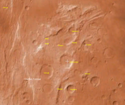
Srīpur is a Martian impact crater , approximately 23 kilometers in diameter. It is located at -31.1°S, 100.8°W, southeast of the crater Dinorwic and northeast of the crater Tugaske . It is named for a town in Bangladesh , and its name was adopted by the International Astronomical Union in 1991. [1] [2]
Page Revisions
| Year | Metadata | Sections | Top Words | First Paragraph |
| 2018 |
74331 characters 1 sections 3 paragraphs 3 images 653 internal links 3 external links |
srīpur 0.572 craterlet 0.258 bangladesh 0.242 tugaske 0.242 dinorwic 0.202 elevation 0.197 meters 0.189 crater 0.173 altitude 0.168 age 0.162 averages 0.155 area 0.136 floor 0.132 epoch 0.132 1991 0.121 |
Srīpur is a Martian impact crater , approximately 23 kilometers in diameter. It is located at -31.1°S, 100.8°W, southeast of the crater Dinorwic and northeast of the crater Tugaske . It is named for a town in Bangladesh , and its name was adopted by the International Astronomical Union in 1991. [1] [2] |
|
| 2017 |
32953 characters 1 sections 3 paragraphs 6 images 160 internal links 3 external links |
srīpur 0.572 craterlet 0.258 bangladesh 0.242 tugaske 0.242 dinorwic 0.202 elevation 0.197 meters 0.189 crater 0.173 altitude 0.168 age 0.162 averages 0.155 area 0.136 floor 0.132 epoch 0.132 1991 0.121 |
Srīpur is a Martian impact crater , approximately 23 kilometers in diameter. It is located at -31.1°S, 100.8°W, southeast of the crater Dinorwic and northeast of the crater Tugaske . It is named for a town in Bangladesh , and its name was adopted by the International Astronomical Union in 1991. [1] [2] |
|
| 2013 |
31250 characters 1 sections 1 paragraphs 6 images 159 internal links 2 external links |
srīpur 0.572 craterlet 0.258 bangladesh 0.242 tugaske 0.242 dinorwic 0.202 elevation 0.197 meters 0.189 crater 0.173 altitude 0.168 age 0.162 averages 0.155 area 0.136 floor 0.132 epoch 0.132 1991 0.121 |
Srīpur is a Martian impact crater , approximately 23 kilometers in diameter. It is located at -31.1°S, 100.8°W, southeast of the crater Dinorwic and northeast of the crater Tugaske . It is named for a town in Bangladesh , and its name was adopted by the International Astronomical Union in 1991. [1] [2] According to a surface age map of Mars based on US Geological Survey data, the area around Srīpur is from the Noachian epoch , which places the area's age at 3.8 to 3.5 billion years ago. [3] The crater floor is relatively flat, except for a small craterlet toward east of the center, and is approximately 6,300 meters above zero altitude in elevation. Its rim averages about 6,800 meters above zero altitude, making it 500 meters deep. The area south of the crater is about the same elevation as the crater floor. [2] |
|
| 2011 |
9951 characters 1 sections 2 paragraphs 2 images 15 internal links 2 external links |
srīpur 0.572 craterlet 0.258 bangladesh 0.242 tugaske 0.242 dinorwic 0.202 elevation 0.197 meters 0.189 crater 0.173 altitude 0.168 age 0.162 averages 0.155 area 0.136 floor 0.132 epoch 0.132 1991 0.121 |
Srīpur is a Martian impact crater , approximately 23 kilometers in diameter. It is located at -31.1°S, 100.8°W, southeast of the crater Dinorwic and northeast of the crater Tugaske . It is named for a town in Bangladesh , and its name was adopted by the International Astronomical Union in 1991. [1] [2] According to a surface age map of Mars based on US Geological Survey data, the area around Srīpur is from the Noachian epoch , which places the area's age at 3.8 to 3.5 billion years ago. [3] The crater floor is relatively flat, except for a small craterlet toward east of the center, and is approximately 6,300 meters above zero altitude in elevation. Its rim averages about 6,800 meters above zero altitude, making it 500 meters deep. The area south of the crater is about the same elevation as the crater floor. [2] |
|
| 2009 |
9951 characters 1 sections 2 paragraphs 2 images 15 internal links 2 external links |
srīpur 0.572 craterlet 0.258 bangladesh 0.242 tugaske 0.242 dinorwic 0.202 elevation 0.197 meters 0.189 crater 0.173 altitude 0.168 age 0.162 averages 0.155 area 0.136 floor 0.132 epoch 0.132 1991 0.121 |
Srīpur is a Martian impact crater , approximately 23 kilometers in diameter. It is located at -31.1°S, 100.8°W, southeast of the crater Dinorwic and northeast of the crater Tugaske . It is named for a town in Bangladesh , and its name was adopted by the International Astronomical Union in 1991. [1] [2] According to a surface age map of Mars based on US Geological Survey data, the area around Srīpur is from the Noachian epoch , which places the area's age at 3.8 to 3.5 billion years ago. [3] The crater floor is relatively flat, except for a small craterlet toward east of the center, and is approximately 6,300 meters above zero altitude in elevation. Its rim averages about 6,800 meters above zero altitude, making it 500 meters deep. The area south of the crater is about the same elevation as the crater floor. [2] |
|
| 2008 |
10867 characters 1 sections 1 paragraphs 2 images 16 internal links 2 external links |
srīpur 0.572 craterlet 0.258 bangladesh 0.242 tugaske 0.242 dinorwic 0.202 elevation 0.197 meters 0.189 crater 0.173 altitude 0.168 age 0.162 averages 0.155 area 0.136 floor 0.132 epoch 0.132 1991 0.121 |
Srīpur is a Martian impact crater , approximately 23 kilometers in diameter. It is located at -31.1°S, 100.8°W, southeast of the crater Dinorwic and northeast of the crater Tugaske . It is named for a town in Bangladesh , and its name was adopted by the International Astronomical Union in 1991. [1] [2] According to a surface age map of Mars based on US Geological Survey data, the area around Srīpur is from the Noachian epoch , which places the area's age at 3.8 to 3.5 billion years ago. [3] The crater floor is relatively flat, except for a small craterlet toward east of the center, and is approximately 6,300 meters above zero altitude in elevation. Its rim averages about 6,800 meters above zero altitude, making it 500 meters deep. The area south of the crater is about the same elevation as the crater floor. [2] |
|
| 2007 |
10905 characters 1 sections 1 paragraphs 2 images 17 internal links 2 external links |
srīpur 0.572 craterlet 0.258 bangladesh 0.242 tugaske 0.242 dinorwic 0.202 elevation 0.197 meters 0.189 crater 0.173 altitude 0.168 age 0.162 averages 0.155 area 0.136 floor 0.132 epoch 0.132 1991 0.121 |
Srīpur is a Martian impact crater , approximately 23 kilometers in diameter. It is located at -31.1°S, 100.8°W, southeast of the crater Dinorwic and northeast of the crater Tugaske . It is named for a town in Bangladesh , and its name was adopted by the International Astronomical Union in 1991 . [1] [2] According to a surface age map of Mars based on US Geological Survey data, the area around Srīpur is from the Noachian epoch , which places the area's age at 3.8 to 3.5 billion years ago. [3] The crater floor is relatively flat, except for a small craterlet toward east of the center, and is approximately 6,300 meters above zero altitude in elevation. Its rim averages about 6,800 meters above zero altitude, making it 500 meters deep. The area south of the crater is about the same elevation as the crater floor. [2] |